קובץ:160658main2 OZONE large 350.png
160658main2_OZONE_large_350.png (600 × 600 פיקסלים, גודל הקובץ: 345 קילו־בייטים, סוג MIME: image/png)
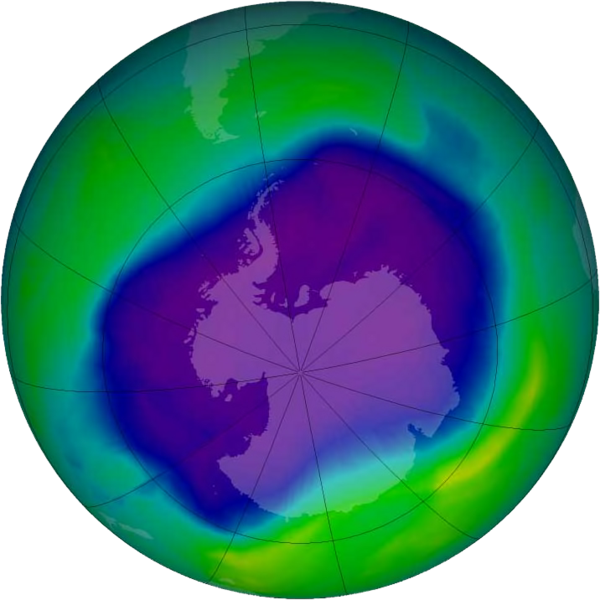
English: From September 21-30, 2006 the average area of the ozone hole was the largest ever observed, at 10.6 million square miles (27.5 million square kilometres). This image, from September 24, the Antarctic ozone hole was equal to the record single-day largest area of 11.4 million square miles (29.5 million square kilometres), reached on Sept. 9, 2000. Satellite instruments monitor the ozone layer, and we use their data to create the images that depict the amount of ozone. The blue and purple colors are where there is the least ozone, and the greens, yellows, and reds are where there is more ozone.
מקור הנתונים http://www.nasa.gov/vision/earth/lookingatearth/ozone_record.html
מקור התמונה http://en.wikipedia.org/wiki/File:160658main2_OZONE_large_350.png
היסטוריית הקובץ
ניתן ללחוץ על תאריך/שעה כדי לראות את הקובץ כפי שנראה באותו זמן.
| תאריך/שעה | תמונה ממוזערת | ממדים | משתמש | הערה | |
|---|---|---|---|---|---|
| נוכחית | 15:56, 6 בינואר 2013 | | 600 × 600 (345 קילו־בייטים) | האזרח דרור (שיחה | תרומות) | English: From September 21-30, 2006 the average area of the ozone hole was the largest ever observed, at 10.6 million square miles (27.5 million square kilometres). This image, from September 24, the Antarctic ozone hole was equal to the record single-... |
אין באפשרותך לדרוס את הקובץ הזה.
שימוש בקובץ
הדף הבא משתמש בקובץ הזה: